Forensic Investigation into the Namibian Genocide
The Centre of Archaeology was invited to join Forensic Architecture (Principal Investigator) on an investigation in Namibia to study the mass graves dating to the genocidal events between 1904-08. Forensic Architecture is a multidisciplinary research group based at Goldsmiths, University of London, that uses architectural techniques and technologies to investigate cases of state violence and violations of human rights around the work. Forensic Architecture were approached by the chair of the Namibian Genocide Association, Laidlaw Peringanda, and the Nama Genocide Technical Committee, to conduct an analysis of the available cartographic, photographic and archival evidence on mass graves and concentration camps in Lüderitz and Swakopmund related to the genocide 1904-1908. In partnership with the Centre of Archaeology team, the aim was to identify and measure any evidence of mass graves —or individual graves— outside of currently known locations surrounding these camps; and to locate concentration camps in these two cities.
The analysis was based upon a variety of material types gathered from public and private sources in Namibia and Germany. Among these are archival photographs, maps and documents covering the period of 1850 to 1950 from the Namibian National Archives, the Colonial Image Archive of Frankfurt University, the Rhenisch Mission Archive Wuppertal, Deutsche Kolonialschule Archive Kassel, the Überseemuseum Bremerhaven, the German Federal Archive. Current and historic maps, satellite and aerial images were sourced from Google Earth, Google Maps and the Namibian Surveyor General. Ground-level photographs were taken by the researchers during their site research in Namibia.
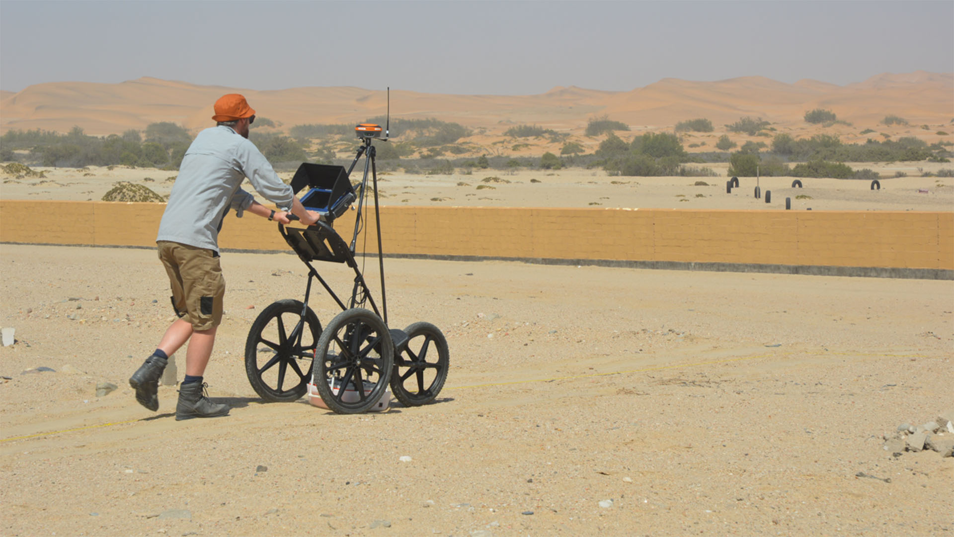
The team conducted field work in Namibia to inform our understanding of the contexts in which the investigation is carried out. To this end, sites of known and suspected sites of several camps and graves were visited, specifically Shark Island, Radford Bay and the former ‘Burenkamp’ in Lüderitz as well as the Swakopmund harbour and the graveyard. A series of non-invasive investigations at these sites too place comprising of a combination of forensic walkover survey, Ground Penetrating Radar (GPR), UAV photogrammetry, and Global Positioning System (GPS) was used to locate potential burial locations and to map the below-ground evidence.

Swakopmund
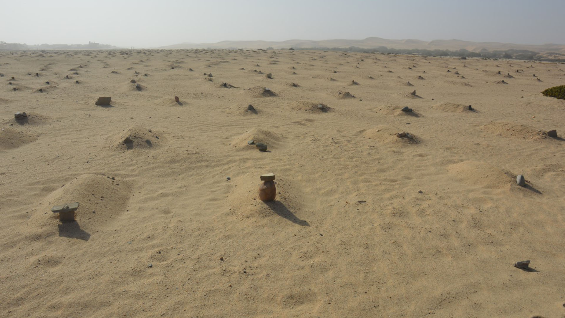
At Swakopmund, it is estimated that between two and three thousand Ovaherero and Nama prisoners died in Swakopmund during the genocide. At a large burial site, situated along the river at the town’s edge, hastily dug graves are each indicated by a mound of sand. Prisoners were forced by their captors to bury their fellow captives in shallow, unmarked graves, often disregarding traditional Ovaherero burial practices. Aerial survey of the site identified just over 2,500 visible burial mounds. In satellite imagery spanning from the 1980s to the early 2000s, the tracks of dune buggies are visible in the same area, criss-crossing the graves. In 2006, descendants of the victims forced the municipality to construct a wall around the unmarked graves to help protect them from further desecration. However, as our cartographic research reveals, this protection has come too late for graves on the northern edge of the burial ground.
The 2006 perimeter wall was constructed along the outer boundaries of a row of luxury houses that were already encroaching on the burial ground. Within a small survey area adjacent to the housing development, a small area with nineteen visible mounds were selected for investigation. GPR data produced subsoil signatures consistent with graves at each mound, confirming the likely presence of human remains. Additionally, the GPR revealed six more likely graves beneath the surface that were not associated with any visible mounds, suggesting that across the burial site, there may be more graves than the 2,500 mounds indicate. This data corroborates testimonies of local activists, that some grave mounds have been flattened during construction works, or afterwards, by residents. Despite appeals to the municipality, those activists claim that little more has been done to protect the mounds.
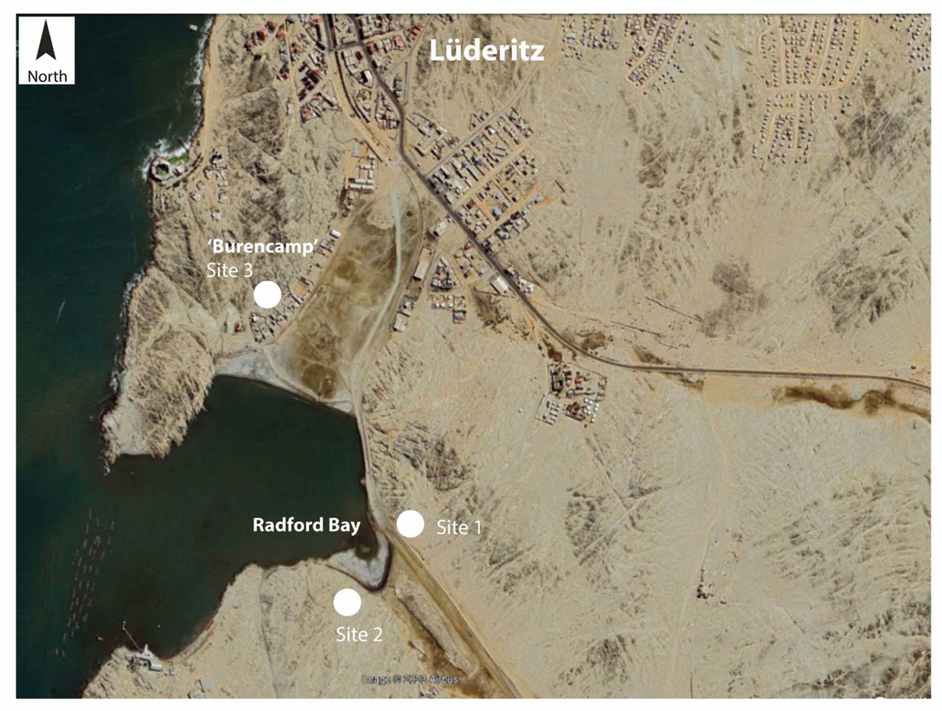
Lüderitz
Shark Island became the most notorious concentration camp in the colony due to its harsh environment, freezing temperatures, and lack of shelter from winds and fog. Dire and unsanitary living conditions and scarce food rations led to outbreaks of typhoid and scurvy. It is estimated that between 1,000 and 3,000 people perished in the camp, most of them through hypothermia and disease, as well as exhaustion from forced labour.
Some sources suggest that as many as 4,000 Herero and Nama inmates died on Shark Island. Yet, the final resting places of the vast majority of those victims is lost to time. Written sources and oral history both suggest that a significant number of bodies were not even buried but thrown directly into the sea. A South African traveller wrote in 1905 that he saw ‘corpses of women prisoners washed up on the beach between Lüderitzbucht and the cemetery’. Multiple descendants of the survivors and victims of the camp gave similar accounts. The waters around the island are thus very likely to be the resting place for many of the camp’s victims. Other victims were buried on land. Evidence points to multiple areas around Lüderitz as possible sites of burial. Some of them lie in the Sperrgebiet, the zone sealed-off for diamond mining since 1908. These very areas are now earmarked for a major ‘green hydrogen’ project, supported by the German government.
After investigation, areas of sand mounds were selected for survey. Among the sand mounds identified at this location, several have substantially larger dimensions than the rest. A further examination of the GPR data profiles has identified at least one feature very likely to be a mass grave. The unmarked graves identified at this location, exposed to the unrelenting elements, are in urgent need of protection and preservation.
For further information and media content, please visit the following links:
- https://forensic-architecture.org/investigation/restituting-evidence-genocide-and-reparations-in-german-colonial-namibia-phase-1
- https://forensic-architecture.org/investigation/shark-island
- https://forensic-architecture.org/investigation/swakopmund